
| Free Flag Facts | ||
| Cilck here - Animated
Flag Large Static Flag |
Eritrea |
|
|
| Introduction | Eritrea |
|
Background:
|
Eritrea was awarded to Ethiopia in 1952 as part of a federation. Ethiopia's annexation of Eritrea as a province 10 years later sparked a 30-year struggle for independence that ended in 1991 with Eritrean rebels defeating governmental forces; independence was overwhelmingly approved in a 1993 referendum. A two-and-a-half-year border war with Ethiopia that erupted in 1998 ended under UN auspices on 12 December 2000. Eritrea currently hosts a UN peacekeeping operation that is monitoring the border region. An international commission, organized to resolve the border dispute, posted its findings in 2002 but final demarcation is on hold due to Ethiopian objections. |
| Geography | Eritrea |
|
Location:
|
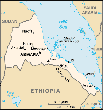
Eastern Africa, bordering the Red Sea, between Djibouti and Sudan |
|
Geographic coordinates:
|
15 00 N, 39 00 E |
|
Map references:
|
Africa |
|
Area:
|
total: 121,320 sq km
water: 0 sq km land: 121,320 sq km |
|
Area - comparative:
|
slightly larger than Pennsylvania |
|
Land boundaries:
|
total: 1,626 km
border countries: Djibouti 109 km, Ethiopia 912 km, Sudan 605 km |
|
Coastline:
|
2,234 km total; mainland on Red Sea 1,151 km, islands in Red Sea 1,083 km |
|
Maritime claims:
|
territorial sea: 12 NM |
|
Climate:
|
hot, dry desert strip along Red Sea coast; cooler and wetter in the central highlands (up to 61 cm of rainfall annually); semiarid in western hills and lowlands; rainfall heaviest during June-September except in coastal desert |
|
Terrain:
|
dominated by extension of Ethiopian north-south trending highlands, descending on the east to a coastal desert plain, on the northwest to hilly terrain and on the southwest to flat-to-rolling plains |
|
Elevation extremes:
|
lowest point: near Kulul within the Denakil depression -75 m
highest point: Soira 3,018 m |
|
Natural resources:
|
gold, potash, zinc, copper, salt, possibly oil and natural gas, fish |
|
Land use:
|
arable land: 3.87%
permanent crops: 0.02% other: 96.11% (1998 est.) |
|
Irrigated land:
|
220 sq km (1998 est.) |
|
Natural hazards:
|
frequent droughts; locust swarms |
|
Environment - current issues:
|
deforestation; desertification; soil erosion; overgrazing; loss of infrastructure from civil warfare |
|
Environment - international agreements:
|
party to: Biodiversity, Climate Change, Desertification, Endangered Species
signed, but not ratified: none of the selected agreements |
|
Geography - note:
|
strategic geopolitical position along world's busiest shipping lanes; Eritrea retained the entire coastline of Ethiopia along the Red Sea upon de jure independence from Ethiopia on 24 May 1993 |
| People | Eritrea |
|
Population:
|
4,362,254 (July 2003 est.) |
|
Age structure:
|
0-14 years: 44.7% (male 977,447; female 972,068)
15-64 years: 52% (male 1,121,077; female 1,147,109) 65 years and over: 3.3% (male 71,620; female 72,933) (2003 est.) |
|
Median age:
|
total: 17.6 years
male: 17.4 years female: 17.7 years (2002) |
|
Population growth rate:
|
1.28% (2003 est.) |
|
Birth rate:
|
39.44 births/1,000 population (2003 est.) |
|
Death rate:
|
13.23 deaths/1,000 population (2003 est.) |
|
Net migration rate:
|
-13.38 migrant(s)/1,000 population
note: UNHCR began repatriating about 150,000 Eritrean refugees from Sudan in 2001 following the restoration of diplomatic relations between the two countries in 2000 (2003 est.) |
|
Sex ratio:
|
at birth: 1.03 male(s)/female
under 15 years: 1.01 male(s)/female 15-64 years: 0.98 male(s)/female 65 years and over: 0.98 male(s)/female total population: 0.99 male(s)/female (2003 est.) |
|
Infant mortality rate:
|
total: 76.32 deaths/1,000 live births
female: 68.64 deaths/1,000 live births (2003 est.) male: 83.78 deaths/1,000 live births |
|
Life expectancy at birth:
|
total population: 53.18 years
male: 51.48 years female: 54.92 years (2003 est.) |
|
Total fertility rate:
|
5.74 children born/woman (2003 est.) |
|
HIV/AIDS - adult prevalence rate:
|
2.8% (2001 est.) |
|
HIV/AIDS - people living with HIV/AIDS:
|
55,000 (2001 est.) |
|
HIV/AIDS - deaths:
|
350 (2001 est.) |
|
Nationality:
|
noun: Eritrean(s)
adjective: Eritrean |
|
Ethnic groups:
|
ethnic Tigrinya 50%, Tigre and Kunama 40%, Afar 4%, Saho (Red Sea coast dwellers) 3%, other 3% |
|
Religions:
|
Muslim, Coptic Christian, Roman Catholic, Protestant |
|
Languages:
|
Afar, Arabic, Tigre and Kunama, Tigrinya, other Cushitic languages |
|
Literacy:
|
definition: NA
total population: 58.6% male: 69.9% female: 47.6% (2003 est.) |
| Government | Eritrea |
|
Country name:
|
conventional long form: State of Eritrea
conventional short form: Eritrea local long form: Hagere Ertra former: Eritrea Autonomous Region in Ethiopia local short form: Ertra |
|
Government type:
|
transitional government
note: following a successful referendum on independence for the Autonomous Region of Eritrea on 23-25 April 1993, a National Assembly, composed entirely of the People's Front for Democracy and Justice or PFDJ, was established as a transitional legislature; a Constitutional Commission was also established to draft a constitution; ISAIAS Afworki was elected president by the transitional legislature; the constitution, ratified in May 1997, did not enter into effect, pending parliamentary and presidential elections; parliamentary elections had been scheduled to take place in December 2001, but were postponed indefinitely; currently the sole legal party is the People's Front for Democracy and Justice (PFDJ) |
|
Capital:
|
Asmara (formerly Asmera) |
|
Administrative divisions:
|
6 regions (regions, singular - region); Central, Anelba, Southern Red Sea, Northern Red Sea, Southern, Gash-Barka |
|
Independence:
|
24 May 1993 (from Ethiopia) |
|
National holiday:
|
Independence Day, 24 May (1993) |
|
Constitution:
|
the transitional constitution, decreed on 19 May 1993, was replaced by a new constitution adopted on 23 May 1997, but not yet implemented |
|
Legal system:
|
primary basis is the Ethiopian legal code of 1957, with revisions; new civil, commercial, and penal codes have not yet been promulgated; also relies on customary and post-independence-enacted laws and, for civil cases involving Muslims, Sharia law |
|
Suffrage:
|
18 years of age; universal |
|
Executive branch:
|
chief of state: President ISAIAS Afworki (since 8 June 1993); note - the president is both the chief of state and head of government and is head of the State Council and National Assembly
head of government: President ISAIAS Afworki (since 8 June 1993); note - the president is both the chief of state and head of government and is head of the State Council and National Assembly cabinet: State Council is the collective executive authority; members appointed by the president elections: president elected by the National Assembly; election last held 8 June 1993 (next election date uncertain as the National Assembly did not hold a presidential election in December 2001 as anticipated) election results: ISAIAS Afworki elected president; percent of National Assembly vote - ISAIAS Afworki 95% |
|
Legislative branch:
|
unicameral National Assembly (150 seats; term limits not established)
elections: in May 1997, following the adoption of the new constitution, 75 members of the PFDJ Central Committee (the old Central Committee of the EPLF), 60 members of the 527-member Constituent Assembly, that had been established in 1997 to discuss and ratify the new constitution, and 15 representatives of Eritreans living abroad were formed into a Transitional National Assembly to serve as the country's legislative body until countrywide elections to a National Assembly were held; although only 75 of 150 members of the Transitional National Assembly were elected, the constitution stipulates that once past the transition stage, all members of the National Assembly will be elected by secret ballot of all eligible voters; National Assembly elections scheduled for December 2001 were postponed indefinitely |
|
Judicial branch:
|
or High Court, regional, subregional, and village courts; also have military and special courts |
|
Political parties and leaders:
|
People's Front for Democracy and Justice or PFDJ, the only party recognized by the government [ISAIAS Afworki]; note - a National Assembly committee drafted a law on political parties in January 2001, but the full National Assembly has not yet debated or voted on it |
|
Political pressure groups and leaders:
|
Eritrean Islamic Jihad or EIJ [leader NA] (also including Eritrean Islamic Jihad Movement or EIJM (also known as the Abu Sihel Movement) [leader NA]); Eritrean Islamic Salvation or EIS (also known as the Arafa Movement) [leader NA]; Eritrean Liberation Front or ELF [ABDULLAH Muhammed]; Eritrean National Alliance or ENA (a coalition including EIJ, EIS, ELF, and a number of ELF factions) [HERUY Tedla Biru]; Eritrean Public Forum or EPF [ARADOM Iyob] |
|
International organization participation:
|
ACP, AfDB, ECA, FAO, G-77, IBRD, ICAO, ICCt (signatory), ICFTU, IDA, IFAD, IFC, IFRCS (associate), IGAD, ILO, IMF, IMO, Interpol, IOC, ISO (subscriber), ITU, NAM, OAU, OPCW, PCA, UN, UNCTAD, UNESCO, UNIDO, UPU, WCO, WFTU, WHO, WIPO, WMO, WToO |
|
Diplomatic representation in the US:
|
chief of mission: Ambassador GIRMA Asmerom
telephone: [1] (202) 319-1991 consulate(s) general: Oakland (California) FAX: [1] (202) 319-1304 chancery: 1708 New Hampshire Avenue NW, Washington, DC 20009 |
|
Diplomatic representation from the US:
|
chief of mission: Ambassador Donald J. McCONNELL
embassy: Franklin D. Roosevelt Street, Asmara mailing address: P. O. Box 211, Asmara telephone: [291] (1) 120004 FAX: [291] (1) 127584 |
|
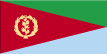
Flag description:
|
red isosceles triangle (based on the hoist side) dividing the flag into two right triangles; the upper triangle is green, the lower one is blue; a gold wreath encircling a gold olive branch is centered on the hoist side of the red triangle |
| Economy | Eritrea |
|
Economy - overview:
|
Since independence from Ethiopia on 24 May 1993, Eritrea has faced the economic problems of a small, desperately poor country. Like the economies of many African nations, the economy is largely based on subsistence agriculture, with 80% of the population involved in farming and herding. The Ethiopian-Eritrea war in 1998-2000 severely hurt Eritrea's economy. GDP growth fell to zero in 1999 and to -1% in 2000. The May 2000 Ethiopian offensive into northern Eritrea caused some $600 million in property damage and loss, including losses of $225 million in livestock and 55,000 homes. The attack prevented planting of crops in Eritrea's most productive region, causing food production to drop by 62%. Even during the war, Eritrea developed its transportation infrastructure, asphalting new roads, improving its ports, and repairing war damaged roads and bridges. Since the war ended, the government has maintained a firm grip on the economy, expanding the use of the military and party-owned businesses to complete Eritrea's development agenda. Erratic rainfall and the delayed demobilization of agriculturalists from the military kept cereal production well below normal, holding down growth in 2002. Eritrea's economic future depends upon its ability to master social problems such as illiteracy, unemployment, and low skills, and to open its economy to private enterprise so the diaspora's money and expertise can foster economic growth. |
|
GDP:
|
purchasing power parity - $3.3 billion (2002 est.) |
|
GDP - real growth rate:
|
2% (2002 est.) |
|
GDP - per capita:
|
purchasing power parity - $700 (2002 est.) |
|
GDP - composition by sector:
|
agriculture: 17%
industry: 29% services: 54% (2001 est.) |
|
Population below poverty line:
|
53% (1993/94) |
|
Household income or consumption by percentage share:
|
lowest 10%: NA%
highest 10%: NA% |
|
Inflation rate (consumer prices):
|
15% (2001) |
|
Labor force:
|
NA |
|
Labor force - by occupation:
|
agriculture 80%, industry and services 20% |
|
Unemployment rate:
|
NA% |
|
Budget:
|
revenues: $206.4 million
expenditures: $615.7 million, including capital expenditures of $NA (2000 est.) |
|
Industries:
|
food processing, beverages, clothing and textiles |
|
Industrial production growth rate:
|
NA% |
|
Electricity - production:
|
220.5 million kWh (2001) |
|
Electricity - production by source:
|
fossil fuel: 100%
hydro: 0% other: 0% (2001) nuclear: 0% |
|
Electricity - consumption:
|
205.1 million kWh (2001) |
|
Electricity - exports:
|
0 kWh NA kWh (2001) |
|
Electricity - imports:
|
0 kWh NA kWh (2001) |
|
Oil - production:
|
0 bbl/day (2001 est.) |
|
Oil - consumption:
|
6,000 bbl/day (2001 est.) |
|
Oil - exports:
|
NA (2001) |
|
Oil - imports:
|
NA (2001) |
|
Agriculture - products:
|
sorghum, lentils, vegetables, corn, cotton, tobacco, coffee, sisal; livestock, goats; fish |
|
Exports:
|
$20 million f.o.b. (2001) |
|
Exports - commodities:
|
livestock, sorghum, textiles, food, small manufactures (2000) |
|
Exports - partners:
|
Italy 36.9%, Germany 16.7%, France 10.3%, US 5.4%, Netherlands 5.2% (2002) |
|
Imports:
|
$500 million c.i.f. (2001) |
|
Imports - commodities:
|
machinery, petroleum products, food, manufactured goods (2000) |
|
Imports - partners:
|
Italy 27.1%, US 15.7%, Germany 7.2%, Ukraine 5.8%, Turkey 5.5%, France 4.5%, Netherlands 4% (2002) |
|
Debt - external:
|
$311 million (2000 est.) |
|
Economic aid - recipient:
|
$77 million (1999) |
|
Currency:
|
nakfa (ERN) |
|
Currency code:
|
ERN |
|
Exchange rates:
|
nakfa (ERN) per US dollar - 9.5 (January 2000), 7.6 (January 1999), 7.2 (March 1998 est.) |
|
Fiscal year:
|
calendar year |
| Communications | Eritrea |
|
Telephones - main lines in use:
|
30,000 (2001) |
|
Telephones - mobile cellular:
|
NA; note - mobile cellular service was introduced in May 2001 |
|
Telephone system:
|
general assessment: inadequate
domestic: very inadequate; most telephones are in Asmara; government is seeking international tenders to improve the system (2002) international: NA; note - international connections exist |
|
Radio broadcast stations:
|
AM 2, FM NA, shortwave 2 (2000) |
|
Radios:
|
345,000 (1997) |
|
Television broadcast stations:
|
1 (2000) |
|
Televisions:
|
1,000 (1997) |
|
Internet country code:
|
.er |
|
Internet Service Providers (ISPs):
|
5 (2001) |
|
Internet users:
|
10,000 (2002) |
| Transportation | Eritrea |
|
Railways:
|
total: 306 km
narrow gauge: 306 km 0.950-m gauge note: railway is being rebuilt (2002) |
|
Highways:
|
total: 4,010 km
paved: 874 km unpaved: 3,136 km (1999 est.) |
|
Waterways:
|
none |
|
Ports and harbors:
|
Assab (Aseb), Massawa (Mits'iwa) |
|
Merchant marine:
|
total: 6 ships (1,000 GRT or over) 19,100 GRT/23,399 DWT
ships by type: bulk 1, cargo 2, liquefied gas 1, petroleum tanker 1, roll on/roll off 1 (2002 est.) |
|
Airports:
|
18 (2002) |
|
Airports - with paved runways:
|
total: 4
over 3,047 m: 2 2,438 to 3,047 m: 2 (2002) |
|
Airports - with unpaved runways:
|
total: 14
over 3,047 m: 1 2,438 to 3,047 m: 1 1,524 to 2,437 m: 6 914 to 1,523 m: 4 under 914 m: 2 (2002) |
| Military | Eritrea |
|
Military branches:
|
Army, Navy, Air Force |
|
Military expenditures - dollar figure:
|
$95.75 million (FY02) |
|
Military expenditures - percent of GDP:
|
12% (FY02) |
| Transnational Issues | Eritrea |
|
Disputes - international:
|
Eritrea and Ethiopia agreed to abide by 2002 independent boundary commission delimitation decision, but demarcation, scheduled to begin in 2003, has been hampered by technical delays and Ethiopian concerns that the decision ignored "human geography" and awarded Badme, the focus of the 1998-2000 war, to Eritrea, demarcation of the boundary has been postponed indefinately; UN Peacekeeping Mission to Ethiopia and Eritrea (UNMEE) monitors a 25 km wide Temporary Security Zone in Eritrea until the demarcation; Sudan accuses Eritrea of supporting Sudanese rebel groups; Eritrea protests Yemeni fishing around the Hanish Islands awarded to Eritrea by the ICJ in 1999 |