
| Free Flag Facts | ||
| Cilck here - Animated
Flag Large Static Flag |
Honduras |

|
|
| Introduction | Honduras |
|
Background:
|
Part of Spain's vast empire in the New World, Honduras became an independent nation in 1821. After two and one-half decades of mostly military rule, a freely elected civilian government came to power in 1982. During the 1980s, Honduras proved a haven for anti-Sandinista contras fighting the Marxist Nicaraguan Government and an ally to Salvadoran Government forces fighting against leftist guerrillas. The country was devastated by Hurricane Mitch in 1998, which killed about 5,600 people and caused almost $1 billion in damage. |
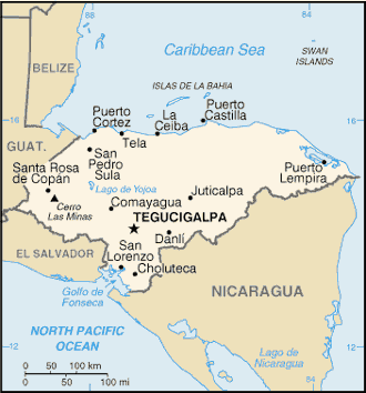
| Geography | Honduras |
|
Location:
|
Middle America, bordering the Caribbean Sea, between Guatemala and Nicaragua and bordering the Gulf of Fonseca (North Pacific Ocean), between El Salvador and Nicaragua |
|
Geographic coordinates:
|
15 00 N, 86 30 W |
|
Map references:
|
Central America and the Caribbean |
|
Area:
|
total: 112,090 sq km
land: 111,890 sq km water: 200 sq km |
|
Area - comparative:
|
slightly larger than Tennessee |
|
Land boundaries:
|
total: 1,520 km
border countries: Guatemala 256 km, El Salvador 342 km, Nicaragua 922 km |
|
Coastline:
|
820 km |
|
Maritime claims:
|
contiguous zone: 24 NM
territorial sea: 12 NM continental shelf: natural extension of territory or to 200 NM exclusive economic zone: 200 NM |
|
Climate:
|
subtropical in lowlands, temperate in mountains |
|
Terrain:
|
mostly mountains in interior, narrow coastal plains |
|
Elevation extremes:
|
lowest point: Caribbean Sea 0 m
highest point: Cerro Las Minas 2,870 m |
|
Natural resources:
|
timber, gold, silver, copper, lead, zinc, iron ore, antimony, coal, fish, hydropower |
|
Land use:
|
arable land: 15.15%
permanent crops: 3.13% other: 81.72% (1998 est.) |
|
Irrigated land:
|
760 sq km (1998 est.) |
|
Natural hazards:
|
frequent, but generally mild, earthquakes; extremely susceptible to damaging hurricanes and floods along the Caribbean coast |
|
Environment - current issues:
|
urban population expanding; deforestation results from logging and the clearing of land for agricultural purposes; further land degradation and soil erosion hastened by uncontrolled development and improper land use practices such as farming of marginal lands; mining activities polluting Lago de Yojoa (the country's largest source of fresh water), as well as several rivers and streams, with heavy metals |
|
Environment - international agreements:
|
party to: Biodiversity, Climate Change, Climate Change-Kyoto Protocol, Desertification, Endangered Species, Hazardous Wastes, Law of the Sea, Marine Dumping, Nuclear Test Ban, Ozone Layer Protection, Ship Pollution, Tropical Timber 83, Tropical Timber 94, Wetlands
signed, but not ratified: none of the selected agreements |
|
Geography - note:
|
has only a short Pacific coast but a long Caribbean shoreline, including the virtually uninhabited eastern Mosquito Coast |
| People | Honduras |
|
Population:
|
6,669,789
note: estimates for this country explicitly take into account the effects of excess mortality due to AIDS; this can result in lower life expectancy, higher infant mortality and death rates, lower population and growth rates, and changes in the distribution of population by age and sex than would otherwise be expected (July 2003 est.) |
|
Age structure:
|
0-14 years: 41.6% (male 1,414,791; female 1,357,537)
15-64 years: 54.8% (male 1,811,757; female 1,843,456) 65 years and over: 3.6% (male 114,791; female 127,457) (2003 est.) |
|
Median age:
|
total: 18.8 years
male: 18.4 years female: 19.2 years (2002) |
|
Population growth rate:
|
2.32% (2003 est.) |
|
Birth rate:
|
31.67 births/1,000 population (2003 est.) |
|
Death rate:
|
6.44 deaths/1,000 population (2003 est.) |
|
Net migration rate:
|
-2.04 migrant(s)/1,000 population (2003 est.) |
|
Sex ratio:
|
at birth: 1.05 male(s)/female
under 15 years: 1.04 male(s)/female 15-64 years: 0.98 male(s)/female 65 years and over: 0.9 male(s)/female total population: 1 male(s)/female (2003 est.) |
|
Infant mortality rate:
|
total: 29.96 deaths/1,000 live births
female: 26.14 deaths/1,000 live births (2003 est.) male: 33.6 deaths/1,000 live births |
|
Life expectancy at birth:
|
total population: 66.65 years
male: 65.31 years female: 68.06 years (2003 est.) |
|
Total fertility rate:
|
4.07 children born/woman (2003 est.) |
|
HIV/AIDS - adult prevalence rate:
|
1.6% (2001 est.) |
|
HIV/AIDS - people living with HIV/AIDS:
|
57,000 (2001 est.) |
|
HIV/AIDS - deaths:
|
3,300 (2001 est.) |
|
Nationality:
|
noun: Honduran(s)
adjective: Honduran |
|
Ethnic groups:
|
mestizo (mixed Amerindian and European) 90%, Amerindian 7%, black 2%, white 1% |
|
Religions:
|
Roman Catholic 97%, Protestant minority |
|
Languages:
|
Spanish, Amerindian dialects |
|
Literacy:
|
definition: age 15 and over can read and write
total population: 76.2% male: 76.1% female: 76.3% (2003 est.) |
| Government | Honduras |
|
Country name:
|
conventional long form: Republic of Honduras
conventional short form: Honduras local short form: Honduras local long form: Republica de Honduras |
|
Government type:
|
democratic constitutional republic |
|
Capital:
|
Tegucigalpa |
|
Administrative divisions:
|
18 departments (departamentos, singular - departamento); Atlantida, Choluteca, Colon, Comayagua, Copan, Cortes, El Paraiso, Francisco Morazan, Gracias a Dios, Intibuca, Islas de la Bahia, La Paz, Lempira, Ocotepeque, Olancho, Santa Barbara, Valle, Yoro |
|
Independence:
|
15 September 1821 (from Spain) |
|
National holiday:
|
Independence Day, 15 September (1821) |
|
Constitution:
|
11 January 1982, effective 20 January 1982; amended 1995 |
|
Legal system:
|
rooted in Roman and Spanish civil law with increasing influence of English common law; recent judicial reforms include abandoning Napoleonic legal codes in favor of the oral adversarial system; accepts ICJ jurisdiction, with reservations |
|
Suffrage:
|
18 years of age; universal and compulsory |
|
Executive branch:
|
chief of state: President Ricardo (Joest) MADURO (since 27 January 2002); First Vice President Vicente WILLIAMS Agasse (since 27 January 2002); Second Vice President Armida Villela Maria DE LOPEZ Contreras (since 27 January 2002); Third Vice President Alberto DIAZ Lobo (since 27 January 2002); note - the president is both the chief of state and head of government
head of government: President Ricardo (Joest) MADURO (since 27 January 2002); First Vice President Vicente WILLIAMS Agasse (since 27 January 2002); Second Vice President Armida Villela Maria DE LOPEZ Contreras (since 27 January 2002); Third Vice President Alberto DIAZ Lobo (since 27 January 2002); note - the president is both the chief of state and head of government cabinet: Cabinet appointed by president elections: president elected by popular vote for a four-year term; election last held 25 November 2001 (next to be held NA November 2005) election results: Ricardo (Joest) MADURO (PN) elected president - 52.2%, Raphael PINEDA Ponce (PL) 44.3%, others 3.5% |
|
Legislative branch:
|
unicameral National Congress or Congreso Nacional (128 seats; members are elected proportionally to the number of votes their party's presidential candidate receives to serve four-year terms)
elections: last held 25 November 2001 (next to be held NA November 2005) election results: percent of vote by party - NA; seats by party - PN 61, PL 55, PUD 5, PDC 4, PINU-SD 3 |
|
Judicial branch:
|
Supreme Court of Justice or Corte Suprema de Justicia (judges are elected for seven-year terms by the National Congress) |
|
Political parties and leaders:
|
Christian Democratic Party or PDC [Dr. Hernan CORRALES Padilla]; Democratic Unification Party or PUD [leader NA]; Liberal Party or PL [Roberto MICHELETTI Bain]; National Innovation and Unity Party-Social Democratic Party or PINU-SD [Olban F. VALLADARES]; National Party of Honduras or PN [Raphael CALLEJAS] |
|
Political pressure groups and leaders:
|
Committee for the Defense of Human Rights in Honduras or CODEH; Confederation of Honduran Workers or CTH; Coordinating Committee of Popular Organizations or CCOP; General Workers Confederation or CGT; Honduran Council of Private Enterprise or COHEP; National Association of Honduran Campesinos or ANACH; National Union of Campesinos or UNC; Popular Bloc or BP; United Federation of Honduran Workers or FUTH |
|
International organization participation:
|
BCIE, CACM, ECLAC, FAO, G-77, IADB, IAEA, IBRD, ICAO, ICCt, ICFTU, ICRM, IDA, IFAD, IFC, IFRCS, ILO, IMF, IMO, Interpol, IOC, IOM, ISO (subscriber), ITU, LAES, LAIA (observer), MINURSO, NAM, OAS, OPANAL, OPCW (signatory), PCA, RG, UN, UNCTAD, UNESCO, UNIDO, UPU, WCL, WFTU, WHO, WIPO, WMO, WToO, WTrO |
|
Diplomatic representation in the US:
|
chief of mission: Ambassador Mario Miguel CANAHUATI
honorary consulate(s): Atlanta, Boston, Detroit, Jacksonville consulate(s) general: Chicago, Houston, Los Angeles, Miami, New Orleans, New York, Phoenix, San Francisco, San Juan (Puerto Rico), Tampa FAX: [1] (202) 966-9751 telephone: [1] (202) 966-2604 chancery: Suite 4-M, 3007 Tilden Street NW, Washington, DC 20008 |
|
Diplomatic representation from the US:
|
chief of mission: Ambassador Larry Leon PALMER
embassy: Avenida La Paz, Apartado Postal No. 3453, Tegucigalpa mailing address: American Embassy, APO AA 34022, Tegucigalpa telephone: [504] 238-5114, 236-9320 FAX: [504] 236-9037 |
|
Flag description:
|
three equal horizontal bands of blue (top), white, and blue with five blue, five-pointed stars arranged in an X pattern centered in the white band; the stars represent the members of the former Federal Republic of Central America - Costa Rica, El Salvador, Guatemala, Honduras, and Nicaragua; similar to the flag of El Salvador, which features a round emblem encircled by the words REPUBLICA DE EL SALVADOR EN LA AMERICA CENTRAL centered in the white band; also similar to the flag of Nicaragua, which features a triangle encircled by the word REPUBLICA DE NICARAGUA on top and AMERICA CENTRAL on the bottom, centered in the white band |
| Economy | Honduras |
|
Economy - overview:
|
Honduras, one of the poorest countries in the Western Hemisphere with an extraordinarily unequal distribution of income, is banking on expanded trade privileges under the Enhanced Caribbean Basin Initiative and on debt relief under the Heavily Indebted Poor Countries (HIPC) initiative. While the country has met most of its macroeconomic targets, it failed to meet the IMF's goals to liberalize its energy and telecommunications sectors. Growth remains dependent on the status of the US economy, its major trading partner, on commodity prices, particularly coffee, and on reduction of the high crime rate. |
|
GDP:
|
purchasing power parity - $16.29 billion (2002 est.) |
|
GDP - real growth rate:
|
2.5% (2002 est.) |
|
GDP - per capita:
|
purchasing power parity - $2,500 (2002 est.) |
|
GDP - composition by sector:
|
agriculture: 14%
industry: 32% services: 54% (2002 est.) |
|
Population below poverty line:
|
53% (1993 est.) |
|
Household income or consumption by percentage share:
|
lowest 10%: 0.6%
highest 10%: 42.7% (1998) |
|
Distribution of family income - Gini index:
|
56.3 (1998) |
|
Inflation rate (consumer prices):
|
7.7% (2002 est.) |
|
Labor force:
|
2.3 million (1997 est.) |
|
Labor force - by occupation:
|
agriculture 34%, industry 21%, services 45% (2001 est.) |
|
Unemployment rate:
|
28% (2002 est.) |
|
Budget:
|
revenues: $607 million
expenditures: $411.9 million, including capital expenditures of $106 million (1999 est.) |
|
Industries:
|
sugar, coffee, textiles, clothing, wood products |
|
Industrial production growth rate:
|
4% (1999 est.) |
|
Electricity - production:
|
3.778 billion kWh (2001) |
|
Electricity - production by source:
|
fossil fuel: 50.2%
hydro: 49.8% other: 0% (2001) nuclear: 0% |
|
Electricity - consumption:
|
3.822 billion kWh (2001) |
|
Electricity - exports:
|
0 kWh (2001) |
|
Electricity - imports:
|
308 million kWh (2001) |
|
Oil - production:
|
0 bbl/day (2001 est.) |
|
Oil - consumption:
|
29,000 bbl/day (2001 est.) |
|
Oil - exports:
|
NA (2001) |
|
Oil - imports:
|
NA (2001) |
|
Agriculture - products:
|
bananas, coffee, citrus; beef; timber; shrimp |
|
Exports:
|
$1.3 billion f.o.b. (2002 est.) |
|
Exports - commodities:
|
coffee, bananas, shrimp, lobster, meat; zinc, lumber (2000) |
|
Exports - partners:
|
US 69.5%, El Salvador 3%, Guatemala 2% (2002) |
|
Imports:
|
$2.7 billion f.o.b. (2002 est.) |
|
Imports - commodities:
|
machinery and transport equipment, industrial raw materials, chemical products, fuels, foodstuffs (2000) |
|
Imports - partners:
|
US 55.3%, El Salvador 4.3%, Mexico 4.2% (2002) |
|
Debt - external:
|
$5.4 billion (2002) |
|
Economic aid - recipient:
|
$557.8 million (1999) |
|
Currency:
|
lempira (HNL) |
|
Currency code:
|
HNL |
|
Exchange rates:
|
lempiras per US dollar - 16.43 (2002), 15.47 (2001), 14.84 (2000), 14.21 (1999), 13.39 (1998) |
|
Fiscal year:
|
calendar year |
| Communications | Honduras |
|
Telephones - main lines in use:
|
234,000 (1997) |
|
Telephones - mobile cellular:
|
14,427 (1997) |
|
Telephone system:
|
general assessment: inadequate system
domestic: NA international: satellite earth stations - 2 Intelsat (Atlantic Ocean); connected to Central American Microwave System |
|
Radio broadcast stations:
|
AM 241, FM 53, shortwave 12 (1998) |
|
Radios:
|
2.45 million (1997) |
|
Television broadcast stations:
|
11 (plus 17 repeaters) (1997) |
|
Televisions:
|
570,000 (1997) |
|
Internet country code:
|
.hn |
|
Internet Service Providers (ISPs):
|
8 (2000) |
|
Internet users:
|
40,000 (2000) |
| Transportation | Honduras |
|
Railways:
|
total: 699 km
narrow gauge: 279 km 1.067-m gauge; 420 km 0.914-m gauge (2002) |
|
Highways:
|
total: 13,603 km
paved: 2,775 km unpaved: 10,828 km (1999 est.) |
|
Waterways:
|
465 km (navigable by small craft) |
|
Ports and harbors:
|
La Ceiba, Puerto Castilla, Puerto Cortes, San Lorenzo, Tela, Puerto Lempira |
|
Merchant marine:
|
total: 250 ships (1,000 GRT or over) 680,784 GRT/765,815 DWT
note: includes some foreign-owned ships registered here as a flag of convenience: Argentina 1, Bahrain 1, Belize 1, British Virgin Islands 1, Bulgaria 1, China 8, Costa Rica 1, Cyprus 1, Egypt 6, El Salvador 1, Germany 1, Greece 18, Hong Kong 3, Indonesia 2, Italy 1, Japan 7, Lebanon 4, Liberia 4, Maldives 2, Marshall Islands 1, Mexico 1, Nigeria 1, Norway 1, Panama 14, Philippines 1, Romania 2, Russia 1, Saint Kitts and Nevis 3, Saint Vincent and the Grenadines 1, Singapore 24, South Korea 12, Spain 1, Syria 1, Taiwan 4, Tanzania 1, Trinidad and Tobago 1, Turkey 2, Turks and Caicos Islands 1, United Arab Emirates 6, UK 1, US 5, Vanuatu 1, Vietnam 1, Virgin Islands (UK) 1 (2002 est.) ships by type: bulk 18, cargo 140, chemical tanker 4, container 7, livestock carrier 2, passenger 2, passenger/cargo 3, petroleum tanker 55, refrigerated cargo 10, roll on/roll off 4, short-sea passenger 4, specialized tanker 1 |
|
Airports:
|
115 (2002) |
|
Airports - with paved runways:
|
total: 12
2,438 to 3,047 m: 3 1,524 to 2,437 m: 2 914 to 1,523 m: 3 under 914 m: 4 (2002) |
|
Airports - with unpaved runways:
|
total: 103
1,524 to 2,437 m: 2 914 to 1,523 m: 18 under 914 m: 83 (2002) |
| Military | Honduras |
|
Military branches:
|
Army, Navy (including marines), Air Force |
|
Military manpower - military age:
|
18 years of age (2003 est.) |
|
Military manpower - availability:
|
males age 15-49: 1,594,266 (2003 est.) |
|
Military manpower - fit for military service:
|
males age 15-49: 948,957 (2003 est.) |
|
Military manpower - reaching military age annually:
|
males: 74,895 (2003 est.) |
|
Military expenditures - dollar figure:
|
$35 million (FY99) |
|
Military expenditures - percent of GDP:
|
0.6% (FY99) |
| Transnational Issues | Honduras |
|
Disputes - international:
|
in 1992, ICJ ruled on the delimitation of "bolsones" (disputed areas) along the El Salvador-Honduras border, but they still remain largely undemarcated; in 2002, El Salvador filed an application to the ICJ to revise the decision on a section of bolsones; the ICJ also advised a tripartite resolution to a maritime boundary in the Golfo de Fonseca with consideration of Honduran access to the Pacific; El Salvador claims tiny Conejo Island, not mentioned by the ICJ, off Honduras in the Golfo de Fonseca; Honduras claims Sapodilla Cays off the coast of Belize but agreed to creation of a joint ecological park and Guatemalan corridor in the Caribbean in the 2002 Belize-Guatemala Differendum; Nicaragua filed a claim against Honduras in 1999 and against Colombia in 2001 at the ICJ over a complex maritime dispute in the Caribbean Sea |
|
Illicit drugs:
|
transshipment point for drugs and narcotics; illicit producer of cannabis, cultivated on small plots and used principally for local consumption; corruption is a major problem; some money-laundering activity |